Mappls MapmyIndia Maps:
Mappls, powered by MapmyIndia, is an advanced mapping application developed in India, offering a variety of features that cater specifically to the Indian landscape. Unlike other mapping services, Mappls emphasizes privacy, accuracy, and a host of features designed to enhance navigation and safety on Indian roads.
Why Choose Mappls?
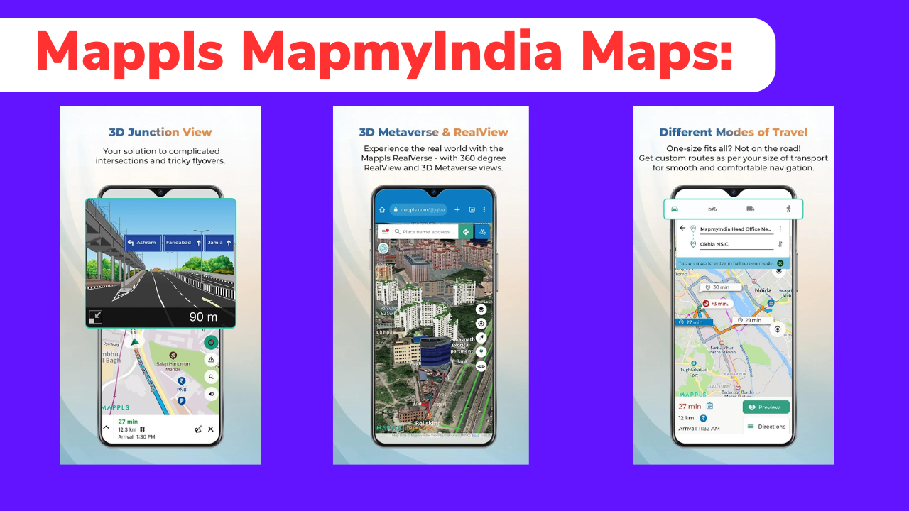
Mappls stands out due to its focus on Indian users, providing highly detailed and accurate maps, including house-level navigation, real-time traffic updates, and safety alerts. The app is a great alternative to Google Maps, offering unique features like 3D Junction Views, RealView, and Mappls ID—a simplified six-character digital address system.
Key Features of Mappls
1.India-Centric Navigation: Mappls excels in providing detailed local maps with house-level accuracy, especially useful in densely populated urban areas. The app’s navigation system includes real-time traffic updates, estimated time of arrival (ETA), and even lane guidance, which is crucial for navigating complex junctions like those found in major cities.
2.Safety Alerts: One of the standout features of Mappls is its focus on safety. The app provides real-time alerts for road hazards, such as speed breakers, sharp turns, potholes, and even speed cameras. These alerts are regularly updated, ensuring that you are always informed about potential dangers on your route.

3.RealView and 3D Junction Views: Mappls offers a unique “RealView” feature, which allows you to view places in 360 degrees, providing a more immersive navigation experience. The 3D Junction View feature helps in making quick decisions at complex intersections, displaying the exact lane you should be in.
4.Mappls ID: This feature generates a unique, six-character digital address code that you can share with others for precise location sharing. This is particularly useful in areas where traditional addresses may be ambiguous or hard to locate.
5.Integration with ISRO: Mappls has partnered with ISRO to incorporate satellite imagery and earth observation data, enhancing the app’s accuracy and detail. This makes Mappls not only a navigation tool but also a comprehensive mapping solution for various use cases, including government projects like the G20 Summit.
Privacy and Data Security: Unlike other map services, Mappls stores all user data on servers located within India, ensuring that your data remains within the country’s borders. This focus on privacy makes it a more secure choice for users concerned about data security.

How to Download and Install Mappls
Android Users:
- Open the Google Play Store on your Android device.
- Search for “Mappls MapmyIndia Maps.”
- Click on “Install” to download the app. Alternatively, you can click here to download it directly.
iOS Users:
- Open the App Store on your iPhone or iPad.
- Search for “Mappls MapmyIndia Maps.”
- Tap “Get” to download and install the app.
Step-by-Step Guide to Using Mappls
Initial Setup:
- Upon opening the app, grant the necessary permissions for location access.
- You can set preferences for notifications and data sharing under settings.
Navigation:
- Enter your destination in the search bar and select your preferred mode of travel (Car, Bike, Walk).
- The app provides turn-by-turn directions, real-time traffic alerts, and ETA updates.
Exploring Nearby Places:
- Use the “Find Nearby” feature to discover places like restaurants, banks, and hospitals.
- Augmented Reality (AR) mode helps in visualizing these places in your surroundings.
Creating a Mappls ID:
- Go to the settings and select “Create Mappls ID.”
- This will generate a unique code that you can share with others for precise navigation.
Safety Features:
- Enable safety alerts under the settings to receive real-time notifications about road conditions, speed cameras, and other potential hazards.
Comparing Mappls with Google Maps While Google Maps is a global leader in navigation, Mappls offers several advantages tailored to Indian users. For example, Mappls provides detailed information on local road conditions, including speed breakers and potholes, which are often missing in Google Maps. Additionally, Mappls’ partnership with ISRO ensures that the app offers the most detailed and accurate maps of India.
However, Google Maps has the upper hand in time estimation for trips due to its reliance on crowdsourced data, making it slightly better in predicting arrival times. But for those prioritizing privacy and local accuracy, Mappls is the superior choice.
[raju_digital_services_download_button timer=”20″ link=”https://play.google.com/store/apps/details?id=com.mmi.maps” button_text=”Download App”]


How to save a planned route